
Notice of Proposed Annexation of Real Property into Bona Vista Water District
May 28, 2026
NOTICE OF PROPOSED ANNEXATION OF REAL PROPERTY INTO
BONA VISTA WATER IMPROVEMENT DISTRICT
A petition has been filed by Patrick Burns, owner of all the private real property, serial number 17-066-0036 in Weber County, Utah to annex that area into the Bona Vista Water District. The service provided by that District is culinary water which was requested by Weber County.
Additional information about the proposed annexation can be obtained from the District office at 2020 West 1300 North, Farr West, Utah. The District’s telephone number is (801) 621-0474 ext. 204.
The petition for annexation is scheduled to be considered by the District’s Board of Trustees at its regular meeting to be held June 29, 2026 at 2:00 pm at the District office at 2020 West 1300 North, Farr West, Utah. Please note the resolution may be delayed for not to exceed 60 days following the public hearing.
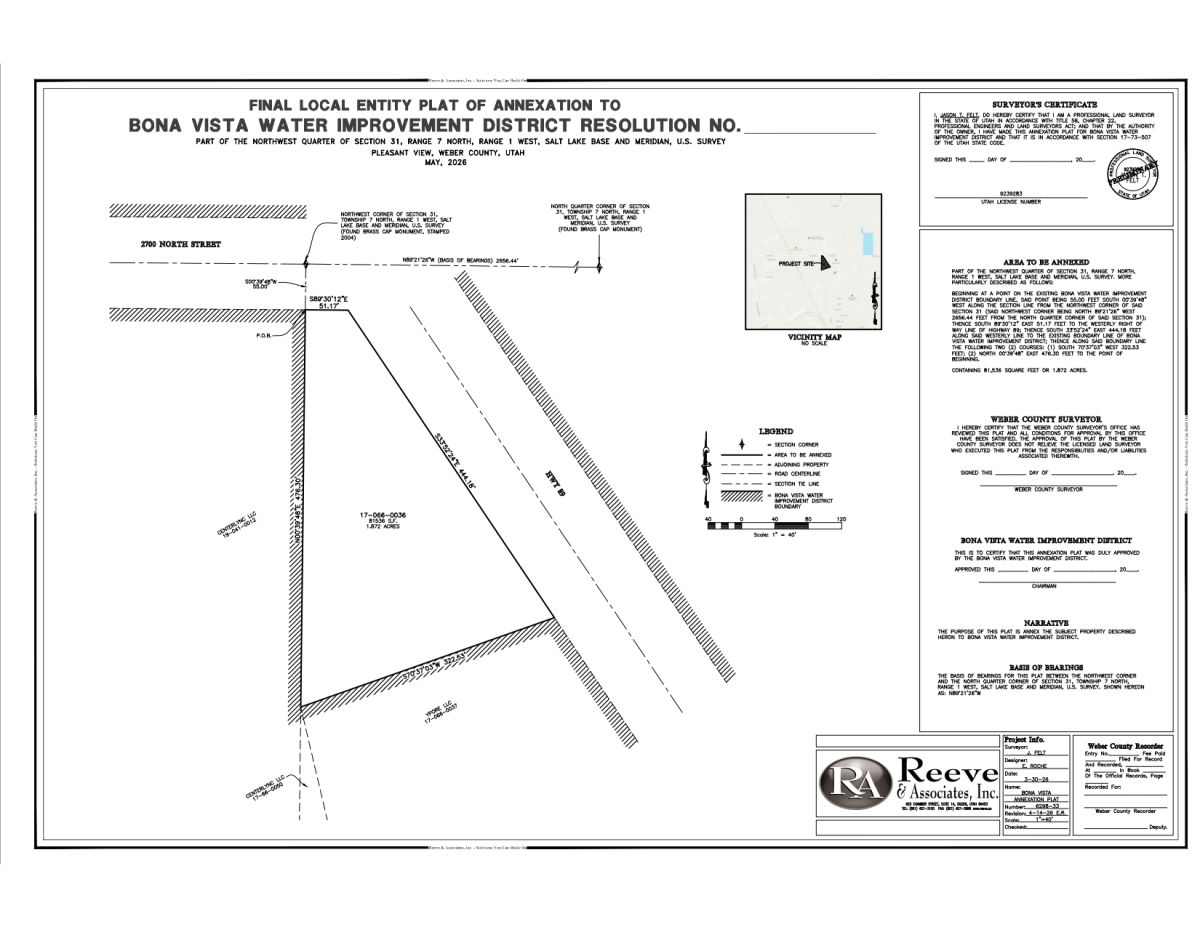
The area to be annexed is shown on the attached plat and is described as follows:
PART OF THE NORTHWEST QUARTER OF SECTION 31, RANGE 7 NORTH, RANGE 1 WEST, SALT LAKE BASE AND MERIDIAN, U.S. SURVEY. MORE PARTICULARLY DESCRIBED AS FOLLOWS:
BEGINNING AT A POINT ON THE EXISTING BONA VISTA WATER IMPROVEMENT DISTRICT BOUNDARY LINE, SAID POINT BEING 55.00 FEET SOUTH 00°39’48” WEST ALONG THE SECTION LINE FROM THE NORTHWEST CORNER OF SAID SECTION 31 (SAID NORTHWEST CORNER BEING NORTH 89°21’26” WEST 2656.44 FEET FROM THE NORTH QUARTER CORNER OF SAID SECTION 31); THENCE SOUTH 89°30’12” EAST 51.17 FEET TO THE WESTERLY RIGHT OF WAY LINE OF HIGHWAY 89; THENCE SOUTH 33°52’24” EAST 444.18 FEET ALONG SAID WESTERLY LINE TO THE EXISTING BOUNDARY LINE OF BONA VISTA WATER IMPROVEMENT DISTRICT; THENCE ALONG SAID BOUNDARY LINE THE FOLLOWING TWO (2) COURSES: (1) SOUTH 70°37’03” WEST 322.53 FEET; (2) NORTH 00°39’48” EAST 476.30 FEET TO THE POINT OF BEGINNING.
CONTAINING 81,536 SUARE FEET OR 1.872 ACRES.